Ham radio for hiking and camping adds the most value when licensed operators need local coordination, a usable amateur repeater covers part of the route, or radio operation is one purpose of the trip. A phone remains the easier tool wherever service works, FRS is often simpler for an unlicensed group, and a satellite messenger or personal locator beacon is the stronger safety layer for remote trips with serious consequences. Terrain, operator preparation, and the location of the receiving station matter more than an advertised mileage figure. This guide helps you assign each tool a realistic job before leaving home.

Start With the Trip, Not the Handheld
In an area with dependable cell coverage, a phone usually outperforms a handheld radio for ordinary communication. Once coverage disappears, the answer becomes route-specific. A high amateur repeater may cover a ridge, trailhead, or campground that has no cellular service, while the next valley may block the same radio completely. The useful question is therefore not, “How far does this radio reach?” It is, “Who must I contact, from which parts of this route, and through what path?”
A recurring mistake I see with new operators is choosing equipment before defining that path. They compare power and antenna length, but have not checked whether anyone in the group is licensed, whether a local repeater is active, or whether the planned campsite sits behind a ridge. Map the trip first, identify the communication jobs, and then decide whether amateur radio solves any of them better than the tools already being carried.
This article focuses on practical outdoor communication and radio activity for US hikers and campers. It does not recommend particular models, teach the licensing process, promise emergency coverage, or turn into an advanced antenna-engineering guide. Readers still deciding where outdoor operation fits can compare the different ways people use ham radio before assembling a field setup.

The Garmin eTrex SE is a handheld GPS navigator for outdoor navigation. It supports multiple GNSS systems and includes wireless connectivity. Its screen is designed to remain readable in sunlight.
Check On AmazonIf you click this link and buy, we earn a commission at no additional cost to you.
Where Ham Radio Adds Real Outdoor Value
The clearest advantage is access to amateur repeaters placed on mountains, towers, and other elevated sites. Two handhelds separated by uneven ground may lose direct contact, yet either operator may still reach a high repeater that rebroadcasts the signal across a much broader area. That can support a scheduled contact with an operator at home, communication between licensed members of a group, or participation in a local net.
Amateur radio also offers more operating flexibility than ordinary short-range walkie-talkies. Depending on license privileges and equipment, an operator may use repeaters, simplex channels, external antennas, established nets, and more than one amateur band. The benefit is not merely having more frequencies. It is being able to select a path that fits the location and the people involved.
At a large campground, for example, licensed participants might coordinate between a trail group, vehicles, and a base camp. During an organized outdoor event, operators may cover separate checkpoints or work through a known repeater. On a radio-focused hike, making contacts can be the activity itself. These are specific jobs with identifiable receiving stations, which is why amateur radio fits them better than a vague plan to carry a radio “just in case.”
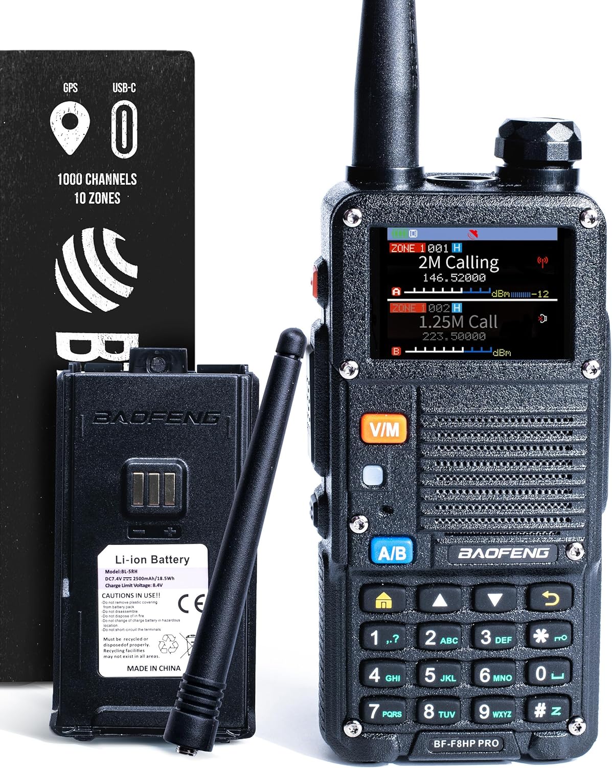
The BAOFENG BF-F8HP PRO is a 10-watt tri-band two-way radio with 1,000 channels. It includes GPS and NOAA weather features along with aviation, VHF, UHF, and 1.25-meter scanning. The radio has an IP54-rated enclosure and a USB-C rechargeable battery.
Check On AmazonIf you click this link and buy, we earn a commission at no additional cost to you.
Terrain Controls Range More Than the Power Number
Most handheld outdoor communication uses VHF or UHF, where ridges, canyon walls, buildings, and the shape of the trail can weaken or block the path. Moving a short distance to higher or more open ground can produce a larger improvement than increasing transmitter power. A hiker may make a clean contact from a saddle or exposed junction, descend into the next drainage, and lose the station completely.
Antenna position changes the result for the same reason. A radio held upright and away from the body usually has a better path than one buried in a pack or pressed against the operator’s torso. An external antenna may improve an otherwise workable path, but it cannot make VHF or UHF pass through a mountain. Advertised range figures that omit terrain are poor planning tools.
Field Note: When I assess a new operator’s outdoor plan, I do not start with the advertised mileage. I ask where the intended station is, what lies between it and the trail, and from which high or open points the contact will be attempted. Those answers reveal far more than another comparison of wattage.
Use terrain as an operating map. Mark ridgelines, open crossings, trailheads, summits, and campsites with a possible view toward the receiving station. Those become planned contact locations instead of places discovered by trial and error after a call fails.

The Nagoya NA-771 is a 15.6-inch SMA-Female handheld antenna designed for VHF and UHF use. Its listed tuning spans 144 to 430 MHz, with optimal transmit ranges of 140 to 148 and 420 to 450 MHz. The antenna is rated at 50 ohms and supports up to 10 watts.
Check On AmazonIf you click this link and buy, we earn a commission at no additional cost to you.
Choose the Tool by the Failure You Must Survive
No single device wins every outdoor comparison. A low-risk campground weekend, a group day hike, and a solo backcountry route have different communication consequences. The useful decision is not which device sounds most capable. It is which function must remain available if the first communication method stops working.
The table below assigns each tool a primary job. This prevents a phone, FRS radio, amateur handheld, satellite messenger, or PLB from being judged by a task it was not selected to perform.
| Trip situation | Best primary layer | Useful role for ham radio | Main limitation to remember |
|---|---|---|---|
| Developed campground with dependable cell coverage | Phone | Local activity, group coordination, or operating practice | Amateur radio adds complexity if nobody else is licensed or listening |
| Family or mixed group needing short-range voice | Compliant FRS radios | A separate link for licensed operators or access to a known repeater | Each independent amateur operator needs the appropriate license |
| Day hike with a verified amateur path | Phone and the normal hiking safety plan | Scheduled check-ins or local operator contact | Coverage changes as the route moves behind terrain |
| Remote trip where loss of contact has serious consequences | Satellite messenger or registered PLB, selected for the mission | Additional local coordination and amateur activity | An amateur call is not guaranteed distress delivery |
| Summit activation or radio-focused hike | Normal navigation and safety equipment | The station and contacts are planned goals of the trip | Radio success does not determine whether the route is safe |
Apply the table to the exact route rather than the trip label alone. A developed campground can still have dead cellular pockets, and a remote trail may cross a ridge with excellent repeater access. The route, the group, and the consequence of a missed message decide the tool assignment.

The ACR ResQLink 410 RLS is a satellite SOS personal locator beacon with integrated GPS. It includes Return Link Service and is listed for global emergency signaling. The beacon requires no subscription for its core distress-alerting function.
Check On AmazonIf you click this link and buy, we earn a commission at no additional cost to you.
Phone, FRS, Satellite, and Ham Radio Solve Different Problems
A phone is the strongest everyday tool where the network works. It handles calls, messages, maps, weather information, photos, and direct access to emergency services. Before leaving coverage, download the route and any information that must remain available offline. Airplane mode or other power-saving choices may also matter because navigation, cold temperatures, photography, and repeated network searching can drain the battery.
FRS is often the practical answer when several unlicensed hikers need uncomplicated short-range voice communication. Compliant FRS radios can be handed to occasional participants without turning the outing into a licensing project. They lack access to amateur repeaters and the wider technical options available to licensed operators, but a smaller feature set is often an advantage when the job is keeping a moving group together.
Satellite messengers and PLBs address communication beyond terrestrial coverage in different ways. A satellite messenger may support two-way messages, tracking, or an SOS function when the device, service, sky view, and subscription conditions allow it. A registered 406 MHz PLB is a dedicated distress device rather than a routine messaging tool. Amateur radio sits beside these options as a flexible operator-to-operator system, not as a duplicate of their satellite functions.

The BTECH FRS-A1 package includes two FRS radios with USB-C charging. The radios include NOAA weather reception, Dual Watch, named channels, and tone-scan features. Their IP54-rated design is built for portable outdoor communication.
Check On AmazonIf you click this link and buy, we earn a commission at no additional cost to you.
Verify the Repeater Path Before Leaving Home
A repeater listing proves only that a system has been documented. It may be outdated, temporarily offline, using changed access settings, or blocked from the trail by terrain. Check the frequency, offset, access tone, location, and current operating status through a reliable local source. Then compare the repeater site with the route instead of relying on straight-line mileage.
A machine twenty miles away on a clear mountain may be easier to reach than one five miles away behind a ridge. Identify high points, open crossings, trailheads, and campsites where a scheduled call has the best chance of working. When practical, test from a comparable location before the trip rather than assuming a map pin equals usable coverage.
Complete this operational check before departure:
- Program the primary repeater with the correct offset and access tone.
- Program a backup repeater and an agreed simplex frequency.
- Confirm that every licensed participant can select each channel without a computer.
- Make a test contact from a relevant area when practical.
- Set check-in times, expected contact locations, and a reasonable delay window.
- Write the plan on paper so a dead phone screen does not erase it.
The missed-contact procedure deserves as much attention as the channel list. Define when the other party should wait, when the hiker should move to the backup location, and when the responsible contact should follow the trip’s emergency instructions. This turns a failed call into a sequence of decisions instead of immediate confusion.

The BTECH PC03 uses an FTDI USB interface for radio programming. The listing names compatibility with BTECH, Baofeng, and Kenwood radios, including the UV-5R, BF-F8HP, GMRS-V2, and UV-82HP. It is sold as a plug-and-play cable that does not require a separate driver installation.
Check On AmazonIf you click this link and buy, we earn a commission at no additional cost to you.
SOTA Makes the Radio Part of the Hike
Summits on the Air, commonly called SOTA, is an organized amateur radio activity built around portable operation from designated summits. Operators who climb and transmit are activators, while other stations contact them as chasers. The program uses summit references, contact logs, points, awards, and a worldwide community. It gives the outing a defined radio objective instead of treating the handheld only as backup equipment.
SOTA also makes signal-path lessons visible. A modest portable station on an open summit may be heard much farther than a more powerful station in a valley because the summit provides a clearer path. Operators must still account for battery capacity, antenna setup, band conditions, access time, and the availability of chasers. Elevation improves opportunity, not certainty.
A summit reference does not guarantee legal access or a safe route. Check land rules, obtain permission where required, stay within license privileges, and set a firm turnaround decision. The activation should be abandoned when weather, darkness, injury, or terrain makes continuing unsafe, even when only one more contact is needed.

The BAOFENG UV-5R Mini is a compact VHF and UHF handheld radio sold here as a two-pack. It provides 999 channels, dual PTT controls, app programming, and USB-C charging. The radio also includes aviation and NOAA reception for additional monitoring capability.
Check On AmazonIf you click this link and buy, we earn a commission at no additional cost to you.
The License Changes How a Group Can Use the Radios
The Technician license covers the common VHF and UHF amateur bands used by most handhelds and local repeaters. That is enough for many outdoor voice plans. The operator still needs to know how to select the programmed channel, listen before transmitting, identify correctly, and make a clear call without searching through menus.
Each person independently operating an amateur station needs the appropriate amateur license. An unlicensed person may speak under the direct supervision of a control operator in a proper station arrangement, but that does not turn separated hikers carrying their own radios into legal independent operators. For a mixed group, FRS may be the common group channel while licensed participants use amateur radio for a separate purpose.
The practical value of licensing is the practice it permits before the outing. A new operator can learn the local repeater, recognize how the radio behaves near terrain, and rehearse a scheduled check-in while mistakes are still harmless. A beginner ham radio overview explains the broader commitment for readers deciding whether that preparation fits their outdoor goals.

The ARRL Ham Radio License Manual, 5th Edition, is a Technician-class amateur radio study guide. It includes the Technician question pool used for exam preparation. The book focuses specifically on preparation for the Technician Class amateur radio exam.
Check On AmazonIf you click this link and buy, we earn a commission at no additional cost to you.
Weight, Power, and Weather Set the Practical Limit
Portable outdoor operation adds more than the radio itself. A realistic kit may include a spare battery, protective bag, written channel plan, microphone or earpiece, and an antenna suited to the activity. A summit activation may justify that extra load, while a fast backpacking route may not. Every item should earn its place by supporting a defined contact or activity.
Battery endurance must be judged by expected use rather than a best-case marketing figure. Long scanning periods, high transmit power, cold weather, frequent calls, and illuminated screens can shorten operating time. Keep the radio dry, protect spare batteries from temperature extremes, and test the controls with gloves if the trip may be cold.
Weather can end the radio activity before it ends the hike. If thunder is heard or a storm is approaching, stop handling or deploying an exposed antenna and move toward appropriate shelter according to the trip’s lightning plan. Do not stay on a summit, ridge, open field, or shoreline to finish a contact. Metal does not summon lightning, but antennas, feed lines, fences, and other conductive objects can carry current when a strike occurs nearby.
For a backpacking station, judge the complete kit rather than the radio’s listed weight. Check that connectors cannot loosen in the pack, controls remain usable with cold or wet hands, and the operator can set up without depending on an online manual. A lighter station that cannot be deployed safely or confidently is not the better field choice.

The BTECH BL-5RHL is a 5,200 mAh lithium-ion battery pack with USB-C charging. It is listed for the BAOFENG BF-F8HP PRO and BL-5RH battery series. The pack provides a separate rechargeable power source for compatible field radios.
Check On AmazonIf you click this link and buy, we earn a commission at no additional cost to you.
What Ham Radio Cannot Promise in the Backcountry
An amateur handheld cannot promise that another operator will hear the call, that a repeater will remain available, or that the signal will escape a canyon. It does not automatically deliver the operator’s identity and location to a rescue coordination system. Someone who receives the call may be able to relay information, but the result depends on reception, accurate details, operator availability, and a path from that station to the appropriate authority.
Amateur communication is also not private. Other listeners may hear the conversation, and ordinary amateur messages cannot be hidden for secrecy. Avoid transmitting access codes or unnecessary medical and personal details. During a genuine emergency, communicate the information needed to obtain effective help, but do not assume the channel is confidential.
This is the place to draw the hard boundary. Amateur radio can support trained people through a known path, and it can be a rewarding reason to hike. It is not a direct substitute for a tool designed and registered for distress alerting.

The ACR ResQLink 400 is a GPS-enabled personal locator beacon that transmits a 406 MHz distress signal. It supports the Cospas-Sarsat system and includes visible and infrared strobe signaling. The beacon requires no subscription and uses GNSS positioning with GPS and Galileo support.
Check On AmazonIf you click this link and buy, we earn a commission at no additional cost to you.
Build a Communication Plan in Five Decisions
A useful plan begins without buying anything. First, identify who must communicate and which services each person may legally use. Second, mark cell coverage, repeater sites, likely radio shadows, and the high or open locations where contact may be possible. Third, assign a normal coordination tool and a separate response for a serious emergency.
Fourth, write the operating details: channels, access tones, call signs, check-in times, contact locations, backup locations, and the response to a missed call. Fifth, run a rehearsal. Test the programming, make a contact when practical, let the person at home follow the written procedure, and remove any step that depends on memory or an internet connection.
Key point: A communication plan is complete only when the group knows what a successful contact sounds like, what a missed contact means, and which action follows next.
The test results should drive later equipment decisions. A poor path may call for a different contact location or communication method rather than a more powerful handheld. When a radio is still the right tool, choose a radio by use case and by the complete field setup it requires, not by the longest feature list.

The Rite in the Rain 735-3X set contains three 3-by-5-inch top-spiral weatherproof notebooks with black covers. Each pocket notebook uses the Universal page pattern and contains 100 pages on 50 sheets. The weatherproof paper and pocket-size format are designed for field note taking in changing conditions.
Check On AmazonIf you click this link and buy, we earn a commission at no additional cost to you.
Final Thoughts: Plan the Path Before Packing the Radio
Ham radio earns space in an outdoor kit when the trip presents a real operator-to-operator job: a known repeater contact, coordination among licensed participants, a scheduled home check-in, or a radio-focused activity such as SOTA. The deciding work happens before departure, when the route, receiving station, terrain, channel settings, power needs, and missed-contact procedure can still be tested.
Start with that path and let the equipment follow. The result may include amateur radio, or it may show that a phone, FRS radio, satellite messenger, or PLB fits the trip better. That is not a failure of ham radio. It is the difference between carrying an interesting device and building a communication plan that matches the outdoors.

The BTECH QHM22 is a heavy-duty IP54-rated speaker microphone for compatible two-way radios. The listing names BAOFENG UV-5R and BF-F8HP models along with radios using the Kenwood K1 interface. Its weatherproof design and single-PTT shoulder-mic format are intended for portable radio use.
Check On AmazonIf you click this link and buy, we earn a commission at no additional cost to you.
FAQs
📻 Is ham radio reliable for hiking?
It can be reliable on a route with a verified repeater or another station in range, correct programming, and favorable terrain. It is not reliable enough to promise contact on every trail, especially in canyons, valleys, or areas without active operators.
⛰️ How far can a handheld ham radio reach in the mountains?
There is no honest fixed mileage. A clear summit path may support a much longer contact than a short path blocked by a ridge, so terrain, antenna position, and repeater elevation matter more than a headline range.
🛰️ Should I carry a satellite messenger or ham radio?
For a remote trip where dependable distress communication is the priority, use a satellite-based tool suited to that mission. Ham radio can add local communication and operator contact, but it should not be the only emergency layer unless the route and communication network have been carefully verified.
👥 Can my unlicensed hiking partners use my ham radios?
They cannot independently operate amateur stations without the appropriate authority. For a dispersed group of unlicensed users, compliant FRS radios are usually the simpler legal option for short-range coordination.
🔋 Do I need a spare radio battery for a day hike?
It depends on the trip length, temperature, radio use, and consequences of losing power. A spare or another charging strategy is sensible when the radio has an assigned communication role rather than being carried only for casual listening.
🗺️ How do I know whether a repeater covers my trail?
Check a current repeater listing and local operator information, then compare the repeater’s location with ridges and valleys along the route. Treat coverage as unconfirmed until the programming and path have been tested from a relevant area.
🎙️ What is SOTA in ham radio?
Summits on the Air is an organized activity in which licensed operators make contacts from designated summits and other operators contact them as chasers. It combines hiking, portable station setup, logging, and awards without replacing normal route safety planning.
⚡ Should I use a portable antenna during a thunderstorm?
No. Stop the radio activity, lower or leave the antenna when it is safe to do so, and move toward appropriate shelter without remaining on exposed high ground. A contact is never worth delaying a lightning response.